by Paul R. Spitzzeri
We move along with this in-depth look at the first substantive study of the City of Industry, conducted in 1964 by the Stanford Research Institute and which covered the first seven years of the city with projections about its future to the end of the decade.
This part looks at a section related to “Projected Demand for Industrial Land, 1963-1970,” which started by observing that “City of Industry is a comparatively small but imortant part of a larger economic body, Los Angeles County.” To help the city plan for its future, the aim of this section was “to consider the possible future demand for industrial land in Los Angeles County” so that “industrial growth in City of Industry can be more realistically estimated.”

A distinction was made between manufactruing and industrial enterprises, with the former more subject to short-term cycles and the latter less affected by that. A table showed that the number of acres of industrial land in the county was projected to grow from just under 20,000 to over 34,000 while the population was estimated to rise from 4.2 to near 8 million from 1950 to 1970.
By comparison, another table showed the steep decline in the county’s agricultural land from some 133,000 acres in 1950 to about 46,000 just a decade later. While no estimate for 1970 was given, it could be asumed that another major decline was in store. The reason for showing this was that much of this former farmland was likely to be converted to industrial uses, including in City of Industry.
Referring to an earlier section starting that the city had just over 450 acres of developed industrial use in 1960 and that nearly 5,000 acres would be available, the authors estimated that an additional 630 acres would be developed by 1970. A table showed this estimate broken down into types of uses, including manufacturing and assembling; warehousing; chemical processing; meat and food processing; and miscellaneous, with the vast majority being in the first category, expected to more than triple from 210 to 644 acres. Sand and gravel operations, dumps, railroad and utility yards, and feed lots were expected to comprise an additional few hundred acres.

It was also stated, however, that “the chances that City of Industry’s competitive situation will improve, and that more industrial usage than that suggested . . . will occur, appear good.” As observed elsewhere, freeway development was crucial to these opportunities, including the San Gabriel River Freeway (I-605) and the Pomona Freeway (SR-60), with the former expected to be completed by 1967 and the latter within three years of that. The “Brea Canyon Freeway,” renamed the Orange Freeway (SR-57) was also in the planning stages. All of these would alleviate the problem identified by realtors about the city’s lack of transportation access and improve its competitive position.
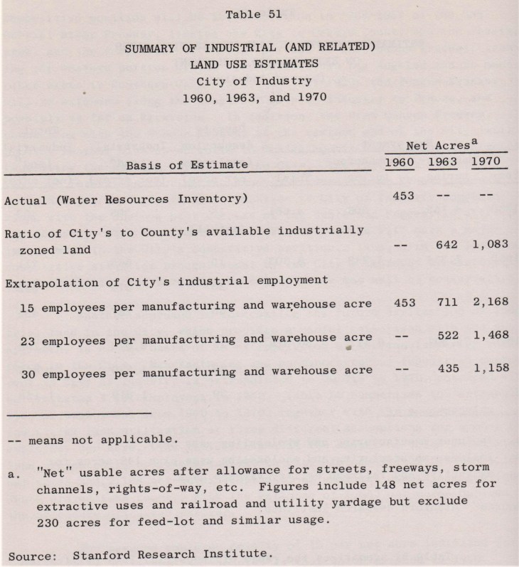
Estimated employment was also explored, with a total of over 30,000 expected by 1970, 80% of this to be in manufacturing. The total in 1960 was just 4,661. Interestingly, the formula of “density per acre” used to estimate the number of workers meant that the amount of developed industrial land could range from 1,158 to 2,168 acres, although above it was stated that 1,080 acres was anticipated, based on another formula for determining land use. This just goes to show how widely varying estimates can be, based on the criteria and methods!

To the point of varying estimates of industrial land used by 1970, another table provided these based on a ratio of industrially zoned land comparing the city to the county and what acreage would be anticipated for different numbers of employees per acre. Net acreage meant allowing for streets and freeways; sotmr channels; railroad rights-of-way and other uses.
As for land prices, there was the caveat that “human emotions and expectations are factors that vitally affect the prevailing land price in an era, and they cannot always be logically analyzed or forecast.” The preference for the authors was to focus on “past price appreciation” and realtors specializing in industrial properties were consulted. Fourteen locations in a four-county area were investigated with trends from 1956-1963 and estimates for 1970 provided.

As noted above, however, predicting prices was potentially a problem and it was stated that projections of land values, based on past appreciation, of $180,000 per acre in City of Commerce and $130-140,000 in Vernon and El Segundo were wildly different than the $20,000 per acre assumed for the east end of the City of Industry and $43,000 for the west end.
A table showed average annual appreciation for the fourteen areas examined, including those in the San Fernando Valley, Los Angeles coastal plain, Orange County and the Inland Empire (including Arlanza, which is a neighborhood of west Riverside.) Rates fluctuated from about 5 to nearly 16 percent, with the lowest in Burbank and the highest in burgeoning Orange County.
The concluding part of this section detailed the influence of freeways on industrial areas, with the development of the Santa Ana Freeway (I-5) being highlighted as critical for industrial development all along the route. While much less of this development was earmarked for the San Bernardino Freeway (I-10) west of Ontario, but those areas that were saw rapid increases in land values.
Freeways were also viewed as important from a public relations and marketing standpoint, because of the large “captive audience” plying these roadways, and having attractive facilites along the routes was noted as being valuable for promotion.
The authors, however, observed that there were varying results from major national studies looking into the effects of freeways on industrial land prices, with one looking at metropolitan Houston suggesting that proximity to a freeway was significant. A Michigan State University study, though, suggested that trying to make a correlation between location and prices was more complicated.

One theory is that concentration of industrial land in city centers led to an overly high value of such land, while suburban areas were lagging in value. The idea is that moving industrial development to the hinterlands, then, providing something of a leveling effect. Orange County’s projected growth of higher values could also be a matter of a better climate and access to more recreation (Disneyland and beaches, probably), as well as more freeways getting to former agricultural land like the massive Irvine Ranch.
In any case, the section ended with the statement that
With the great improvement in access that will be accomplished by the completion by 1970, and before, of the San Gabriel River, Pomona, and Brea Canyon [Orange] freeways, a continuation of prior appreciation trends in the City of Industry seems reasonable.
It was expected that the large variance in prices in the west (much higher) and east (far lower) ends of the city would be stabilized because of the uniformity of access to these freeways.
Next week, we continue with a look at the “City of Industry Relative to the Region.”